Posted by: thecaliforniacoastalmission | August 23, 2010

The Final Stretch

Greetings from San Diego. After 48 days of paddling, we have reached Scripps Institute of Oceanography, the goal of our trip! Since our last post, we have paddled the final 100 miles from Santa Monica to La Jolla.

In Venice Beach we met the friendly folks at ASR. The company designs artificial reefs, submerged geotextile bags that dissipate wave energy to prevent beach erosion. The reefs can also create habitat for marine life and, if conditions are right, create good surf breaks. Needless to say Lane, Michael, and I were quick to jump on the opportunity to tour ASR. Thank you Matt Inkeles for showing us around Venice Beach office and giving us a taste of what ASR aims to do. Starting at Santa Barbara, we have kayaked past countless seawalls and jetties built to keep sand on the beach. There is hardly a mile of unobstructed coastline in Southern California. Seeing a creative way to go about dealing with California’s erosion problem was inspiring.

Before leaving Venice Beach, we stocked up with three bottles of ginseng extract from Windward Farms market. We weren’t sure when we would need the ginseng boost, but with 100 miles to paddle in 7 days, the moment would was sure to come.

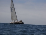
We made quick time through Orange County. At the Huntington Beach Pier we paddled right up to the US Open of Surfing to see the legendary Kelly Slater and Rob Machado trade waves 100 yards off our kayaks. Of the tens of thousands of spectators, we had the most unique seats in the house. Both Kelly Slater and Rob Machado were usurped by young Aussie upstart Ace Buchan in the 30 minute heat. After the final horn, we paddled away chuckling at our good fortune. Up in Monterey, we kayaked past the tents left behind from the US Open of Golf at Pebble Beach, and now we were paddling past surfing’s equivalent of the same event.

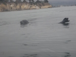
Off Laguna Beach Dana Point, Michael and I were awestruck to see a pod of 100 + dolphins whisking towards us. The dolphins swam within feet of the kayak while splitting up into groups and darting after fish. Unlike the larger bottlenose dolphins we had nearly exclusively seen up to this point, we believe these were Pacific White sided dolphins due to their two-tone fins and majestic white side marks. It was a humbling sight indeed.

That night we stayed with the Stanford Water Polo team in San Juan Capistrano. Thank you to the Laforge family for the food and floor space. We’ll never forget 205 pound defender Andrew Laforge pulling out a gallon size bag full of cooked beef chunks to offer us a snack. Maybe next time dude.

The next day we paddled the final leg of the OC into San Onofre. Although we didn’t see any real housewives, the coast from Laguna Beach down to San Clemente is a gorgeous stretch, from the spectacular mansions on private beaches to perky Nuclear Power reactors.

The Camp Pendleton Marine Base separates San Diego and Orange County. We had been nervous about paddling around the base for weeks, but camp officials assured us we would be safe as long as we kept well offshore. If the deafening blasts we heard at the base’s boundary weren’t enough to keep us away, we received warning on the Local Notice to Mariners that the Marines would be testing Expeditionary Fighting Vehicles (EFVs) during the period we planned to paddle around Pendleton. The Coast Guard advised avoiding the area, as the EFVs are difficult to steer, reach high speeds, and kick up some large wakes. Without deliberation we decided the skip the Camp Pendleton section of the coast.

For justification of our decision, check out this video of an EFV:

That night we stayed with my Uncle George and Aunt Heidi before launching at Oceanside Harbor the next morning. Thanks for the berry pancakes, warm showers, and real beds. We were feeling a little too pampered by morning, so we decided to make it a long day and paddle the 20 miles to my family’s place in Del Mar.

Paddling into Del Mar was a beautiful end to the trip. It was a classic warm Southern California evening, with the sun setting over the glassy sea. It seemed as though all the surfers forgot what they were doing for a moment to watch the sun sink over the horizon. Tingling with excitement (or possibly ginseng extract), we paddled rhythmically to familiar shores.

We struck up conversation with a friendly paddle boarder just off the Del Mar Rivermouth.

“Gorgeous sunset eh”

“Yea, you’ve got the best seat in the house” replied Lane.

“Where’d you guys launch from?”

“Monterey”

“Oh… I came from right there” pointing in to shore “I hope you guys took a few breaks”

My brothers paddled out on their surfboards to greet us, with friendly splash battle ensuing. The swell was up, and Lane and I had to time our landing correctly, mostly to save ourselves the embarrassment of flipping our kayaks in front of my family. Pulling onto the beach, hugs were exchanged and my dad’s fish tacos were passed around. With only one more day of kayaking to go, we feasted and rested, knowing that we were own the brink of finishing something special.

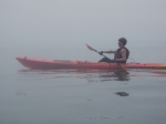
On Wednesday the 11th we launched from Del Mar and paddled the final 7 miles into the Scripps Institute of Oceanography in La Jolla. The warm water got us thinking back to the frigid seas of Monterey nearly two months earlier. We recalled our former selves like seasoned war veterans.  We really had no idea what we were getting ourselves into. But here we were down in idyllic La Jolla, with nearly the entire lower half of California under our belts.

At 2:15 Pm we landed in at the Scripps Institute of Oceanography to a chorus of hoots and cheers (mostly our own) and generous Mexican feast. In a funny coincidence Laura, one of our friends at Stanford who interns at Scripps, was tasked with organizing a little reception for us. Thank you to Laura, Benjamin, Rivah, and professor Ron Burton for the warm welcoming and warm tamales. We enjoyed sharing stories from the coast and hearing about the incredible work at SIO.

Awash with nostalgia, Lane Michael and I loaded the kayaks on top of the Suburban, and did something he hadn’t done in nearly two months – headed north. As the last notes of the trip’s music still ring, Lane, Michael, and I would like to thank all the people that helped us dream up and carry out this incredible trip.

The Montgomery Family

The Taylor Family

The Hartman Family

The Bill Lane Center for the American West

The Stanford School of Earth Sciences

Almond Surfboards

Mysterioso Fleece

Signing off,

Ian, Lane, and Michael

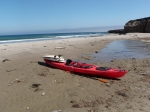
PS. If this blog put anyone in the mood to buy two well-loved kayaks, please call Ian Montgomery at 310-600-0431.

Greetings from Los Angeles! We are taking a few days of rest before setting off on the final leg of our trip. Over the past 10 days, we have kayaked 100 + miles from Gaviota down to Santa Monica. The rugged coastal expanse of the Central Coast has finally been replaced by urban sprawl.

Although we were a little uneasy about leaving the Central Coast behind, landing in Santa Barbara meant our first coastal In n’ Out Burger – something we’ve been dreaming about since Big Sur. In the 1830’s Richard Henry Dana suggested the reason his crew was stayed so healthy when sailing off California was the pound or two of beef they ate each day. We had a lot to live up to, but Michael managed with two double doubles.

At UC Santa Barbara, we spoke with Dr. Kevin Lafferty, manager of the adjacent Coal Oil Point Reserve, about threatened marine species and how to shape redwood and agave surfboards. Coal Oil Point Reserve encompasses 58 acres of protected coastline just north of the UCSB, straddling the boundary of Southern and Central California. To the south lies Isla Vista, UCSB’s college town, and to the north the coastline has the more bucolic feel we have grown accustomed to.

We mentioned to Dr. Lafferty that the last sea otter we had seen was just a few miles south of Point Conception. He told us about the monitoring he has done on sea otter populations. Although sea otters populations have rebounded tremendously, the otter has been slow to move south of Point Conception. The otters we saw just around the Point were part of a small group of about 45 otters that make up the southern most colony. Dr. Lafferty is still trying to determine why the otters have slowed their southward proliferation at Point Conception, but he suspects the male otters stick to where the female otters make their homes. Without females south of Point Conception, the male population just doesn’t seem to have a reason to push south.

On that note with a few sly grins exchanged around the table around the table, the conversation took a turn towards surfing. We shared stories about the empty perfect waves we rode to the north, and Dr. Lafferty took us step by step through how to shape surfboards out of agave and redwood. Our eyes lit up as he described the joys of taking something from its creation to its final use. He says he wouldn’t recommend the process to anyone, but the surfboards, much heavier than our modern foam and fiberglass creations, embody a more natural way to enjoy the ocean.

Further south, in the city of Santa Barbara, we spoke with Dr. Jan Timbrook, Curator of Ethnography at Santa Barbara Museum of Natural History, about the Chumash history of the region.

“So did you guys really paddle around Point Conception? I’m curious because the Chumash wouldn’t even think about taking their plank canoes up there”

“Yep we did… and we can see why” we all replied.

Jan spent the next hour with us talking us through the making of the Chumash plank canoe, the tomol. These beautiful old boats were constructed from the same kinds of materials we saw washed up on the beaches. Redwood logs that drifted down from the Central Coast were split into planks using rock tools. The planks were glued together using tar deposits from the beach, a little harder than the stuff that blackens of Santa Barbara beachgoers to this day. To give the canoes a dash of panache, bright abalone shells were crushed up and thrown against the drying tar. The shimmering vessels were said to look like dolphins cresting through the water as they made trips to and from the Channel Islands. We were all blown away at how a seaworthy canoe could be completely manufactured just from what lays around on the beaches of Santa Barbara.

Jan researches Chumash ethnobotany, how the Chumash culture used the local fauna in their everyday lives. I’ve been plagued with some pretty savage cases of poison oak over the last few years, and with Jan’s help and some old Chumash knowledge I may have found a cure. We’ll let you know how well Mugwort leaves work to cure poison oak.

We said our goodbyes to Santa Barbara, and paddled the boats quickly through Ventura to make it home to Los Angeles. I couldn’t be happier to be home. We slept in real beds, ate real food, took real showers, and ate more real food.

They guys have taken to LA like a sprinkle of cinnamon to a soy latte. Michael made a name for himself climbing rope at Muscle Beach, while Lane was spotted sipping Starbucks while strolling down the Avenue of the Stars (sorry buddy I had to).

After a friend John’s car ran out of battery on the Sunset Strip in Hollywood, Lane and Michael had the chance to show their true colors. I pulled up adjacent to the dead Toyota, Lane and Michael jumped out, rigged the cables, and got the car started in less than 30 seconds.

“Positive!”

“YEP”

“Black Negative”

“YEP”

“Grounded”

“Turn it”

“Go Go Go!!”

The BMW’s and Porcshe’s stalled behind us were too dumb founded at the undercover pit crew to even honk.

Sorry for the lack of updates over the last 10 days, it has been difficult to find a free moment in hectic Southern California. We seem to attract the action wherever we pull up, maybe it’s the kayaks, maybe it’s Lane’s carefully sculpted golden hair, or it may have something to do with Michael’s rugged good looks (a little too rugged for a certain West Los Angeles private establishment but that’s a story for another time).  Regardless finding time to put pen to paper has been tough as of late.

Thank you to the Montgomery Family, the McGuire Family, the Patterson family, SMDC, Nicole “Tiny Dancer” Rodriguez, Matt “Not-so-tiny Dancer” Goodyear, Antonio Cerruto, Xandra Clark, and Avantika Agarwal, Mikey Sutton, the Black Tie Rebels, Pixiekill, Matt Funk and Will McCabe, and the ravenous mammals in the Santa Barbara Mountains for making this stretch of coast incredible.

And thank you to Santa Monica, Beverly Hills, Hollywood, Venice Beach, and East LA for keeping things lively.

Posted by: thecaliforniacoastalmission | July 20, 2010

Point Conception: Experience the Winds of Change

For centuries, Point Conception has marked the most dangerous passage on the West coast. Countless ships have been lost off in those waters. Back in 1834 after a harrowing passage in gale force winds, Richard Henry Dana Jr. called Point Conception “the Cape Horn of California… where it begins to blow the first of January and blows until the last of December.”

In planning the trip, we prepared ourselves for the possibility of skipping Point Conception completely. Some stretches of coast are just not meant to be crossed, especially in plastic kayaks. Regardless, we camped out at Jalama Beach for a few days, Point Conception looming in the distance, waiting to see if the winds would lay off.

For three days we bided our time contently exploring the coast and surfing in the company of friends old and new. On Monday around midday the wind totally died off. We talked with both the lifeguard and Lompoc local Dave, who both agreed that since the winds hadn’t yet picked up, conditions that afternoon would be about as good as they ever would be. Both added that as soon as we were around Point Conception, things would be downhill to San Diego. They turned out to be right, we just didn’t expect that we still had so far uphill to go.

With the winds light and skies clear, Michael and I said our goodbyes at Jalama Beach. Lane wished us well from ashore, waiting with the SPOT GPS satellite messenger and VHF radio if need be. After punching through the meaty Jalama shorebreak, Michael and I elected to stay inside the shelter of the kelp beds for as long as possible.

Point Conception juts out eerily into the Pacific, its pale granite face out of place in the sandstone cliffs. There two currents converge; the cool waters of northern California meet the warm waters of southern California, kicking up some formidable winds.

As Conception grew closer and closer, glassy seas gave way to more textured seas. About a mile out from the point, small tar cakes started lapping against the hull of our kayaks. Michael picked one up to “investigate” later, but the tar quickly melted under the sun, giving one of our boats a little cosmetic boost.

As the point neared, the winds and swell continued to grow. The winds were up to 18 knots, causing swell to break in open ocean. Michael and I bobbed in and out of view in the growing swell, although we were no more than 25 feet from one another. Waves broke into our laps, filling the kayaks up with water. As the swell and wind combined to push us into the point, we were forced to balance burst of sprinting sideways through the swell and backpaddling through walls of breaking water.

There was one particular moment that stands out, a large swell capsized my kayak and filled Michael’s entire cockpit with water. After righting the boat, we both looked at each other and thought “Lets get the hell out of here”. 4 ft of swell and 20+ knots winds were pushing us into the rocks. It was a GO moment if there ever was one. Our bodies pumped with adrenaline for the next half hour as we navigated through the mayhem.

Just as abruptly as the winds picked up, they once again laid off. Michael turned to me with a dazed grin and let out the understatement of the trip “Well I can definitely see why a lot of ships sink off that Point.” Me too man, me too.

Around Government Point, half a mile south of Conception, the winds turned, the sun shone through and Southern California greeted us with open arms. We beached the boats, embraced, and sat down in the paradise-like Hollister Ranch. Two shipwrecked sailboats on the beach next to us reminded us of the intense conditions just offshore, but for the moment we were in the safe cradle of Southern California.

The next 12 miles through The Ranch felt dreamlike, and a pod curious of dolphins followed us for three of four miles.  We landed in Gaviota to glassy seas just as the sun was setting.

“Where did you guys come from?” a few curious locals asked us.

“Jalama, just around Conception”

“That’s a long way from here”

The memory of Point Conception flashed through my mind and the distance didn’t even begin to describe that journey.

“Yeah, sure is,” was all I could say.

At this Point in our trip, we enter Southern California and leave the Central Coast behind. Lane, Michael, and I all agreed that the natural beauty of Central California was incredible, but the experiences that stand out to us the most come from the immense open hearted kindness of the central coast locals. From Monterey down to Jalama, we have shared some pretty incredible memories with people we have come across. Thank you specifically to Larry and Chris at Bottcher’s Gap, our European friends and the Bakersfield boys in Big Sur, Don at Cambria, Dan at the Guadalupe Dunes Center, Dave and Veronica at Jalama, Matt, Clayton, and my family for sharing the experience with us.

Peace, Love, and Happy to Be in Socal

Ian, Michael, and Lane

New story about us in the SLO Tribune

http://www.sanluisobispo.com/2010/07/10/1211302/monterey-to-san-diego-research.html

We have now made it through San Luis Obispo county and are passing into Santa Barbara. Over the past few days we have kayaked from Morro Bay, around the sinister looking Diablo Canyon Nuclear Power Plant, passed the Pismo Dunes Vehicle Recreation Area and into Santa Barbara County.

Approaching the Diablo Canyon Nuclear Power Plant in the fog was surreal. The reactors are surrounded by miles of untouched coastline, adding to the “secret lair” feel of the experience. Michael and I both starting humming the James Bond theme song as we approached the rocks outside Diablo Canyon. The kelp beds surrounding the rocks were some of the thickest we have seen all trip, and we weren’t quite sure whether to be reassured or alarmed by this realization.

Further down the coast, we spotted a remote beach from our kayaks and chose to go ashore. Large cliffs make the beach inaccessible from land, and there wasn’t a footprint on the sand. The only things resembling footprints were a few pieces of plastic debris washed above the high tide line: a quiet reminder of the far-reaching influences of our actions.  We photographed quadrats of the intertidal, finding some of the largest goose barnacles we have ever seen. We combed the sand, checked out abalone shell sea glass and marveled to ourselves that these untouched slices of paradise can exist in a state with 30 million people.

Later in the day, we had the privilege of speaking with Don Canestro, the manager of Rancho Marino Reserve in Cambria. The reserve extends across 500 acres of pristine coastal habitat ranging from rocky intertidal to coastal grasslands and Monterey Pine forests. That morning, Don had been out monitoring the reserve’s population of Black Abalone. Since ocean warming during the El Nino winter of 82-83, black abalone populations across California declined drastically. The culprit behind the deaths is withering foot syndrome, a bacterial infection that attacks the digestive systems of abalone. Rancho Marino monitors the black abalone population for signs of withering foot syndrome.

Don gave some historical perspective by talking about abalone population cycles dating back to the Chumash times. Large piles of red abalone shells, the leftovers from massive Chumash seafood feasts, have been found on the reserve, suggesting that red abalone and black abalone populations rise and fall in alternating cycles. Will withering foot syndrome be just another chapter in this cycle of alternating population cycles? Don said that if his work as a biologist has taught him anything, it is that populations move in cycles. Nonetheless, he continues to study Rancho Marino with inspired excitement.

Further south in Avila, we happened upon a group of surf fly fisherman casting for halibut. They were enthusiastic about the days potential, but have noticed declines in halibut number since they began fishing years ago.

From Avila, we kayaked south to Pismo Beach, camping in the thick of the Oceano Dunes Vehicle Recreation Area. After three weeks of Central Coast solitude, falling asleep to the sounds of ATVs puttering past our tents was a shock to the system. Pismo Beach is the only place in California where you can legally drive out onto the sand, and this weekend saw no shortage of takers.

To give some balance to our Pismo experience, the three of us kayaked further down to the farming town of Guadalupe. Although only ten minutes south of Pismo Beach on Highway 1, Guadalupe is a world away from Pismo. While Pismo feels like the summer hang out for the off road enthusiasts of Fresno and Bakersfield, Guadalupe is a quiet farming town that operates largely in Spanish.

In Guadalupe we met Dan McElhinney and Mario Castellanos from the Guadalupe Nipomo Dunes Center. The Dunes Center was founded in the wake of the Unocal oil spill to empower to community of Guadalupe through ecological education.

Mario and Dan stressed the importance of locating the center in Guadalupe, and not in Pismo Beach where the money and tourism is located. The goal at the Dunes center is to get the local community of Guadalupe, where the average person has a ninth-grade education, interested in education through exposure to natural sciences. The secondary goal is the give to community of Guadalupe a sense of ownership over the Dunes. Dan hopes the tangible effects of the Dunes Center will be measured not only in acres of restored dunes, but also in more high school kids from Guadalupe choosing to attend college. Lane, Michael and I were all impressed with the center’s use of environmental science to inspire kids to pursue higher education. We also realized how lucky we are to live the lives we live.

Dan was gracious enough to sit down a chat with us for nearly an hour about the history and ecology of the Dunes. We learned about the greatly varied human history in the Dunes. Recently Pirates of Caribbean III was filmed in the dunes, and Johnny Depp and Keira Knightley sightings spiced things up in Guadalupe. Back in the 20’s, The Ten Commandments was filmed in the area as the dunes of San Luis Obispo are a much more convenient location that the dunes of Egypt. After filming was completed, the producers elected to bury the entire set in the sand, pyramids and all. Apparently they were worried about leaving the set exposed, as competing movie companies could come along and shoot similar films using the same set. Locals have been finding Egyptian “artifacts” in the Dunes ever since.

The dunes stretch from Pismo Beach in the north to Point Sal in the south.  Where vehicle traffic used to be allowed over the entire dunes, it is now limited to about 10% of the total dune area. A reason for this was the infamous snowy plover, one of the two endangered bird species in the dunes, lays its eggs under the sand. Thus much of the dunes are roped off to protect the snowy plover population.

For the curious, Dan mentioned a healthy Dune ecosystem consists of roughly 60% exposed sand and 40% dune vegetation.

Dan also told us about the Dunites, a group of Bohemian pre-hippies that scraped out an existence for themselves in the Dunes in the 20’s, 30’s, and 40’s. These disenfranchised souls spent their days painting and writing poetry, none of which ever reached a popular audience. That afternoon, I wandered out into the dunes searching for the last of the Dunites, but all I found were ATV tracks and Tecate cans.

As Steinbeck and Ricketts said, ecology is ALL. In Pismo’s case, the ecology consists of everything from the Pismo motorheads to the fragile snowy plovers, all interacting together to form the superorganism that is the Guadalupe-Nipomo Dunes.

Heavy winds forecasted, so we may be in the area for a while. That’s all for now. I’ll leave you with some haikus from the trip.

Peace and Love,

Ian

Camping Utensils

Spoon and fork is spork

But what of the knife-fork-spoon?

The trusty knorkoon.

South of Big Sur

Slipping our way south

Time loses significance

Spent bean tins mark days

Diablo Canyon

Behind foggy rocks

Nuclear reactors hide

I feel like James Bond

Pismo Beach

Snowy plovers, hicks

Endangered and a danger

Side by side in sand

Our SLO Diet

Our perplexed bodies

Chowder Burritos and Fries

Breakfast, Lunch, Dinner

—————————————–

Rancho Marino Reserve

http://nrs.ucop.edu/Kenneth-Norris-Rancho-Marino.htm

The Dunes Center

http://www.dunescenter.org/

Posted by: thecaliforniacoastalmission | July 8, 2010

Back on the Water!

So, after many days, we have finally taken to the water again.  Over the past 3 days we have kayaked about 45 miles from Point Piedras Blancas to Spooner’s Cover near Morro Bay.  We are definitely stoked to be making progress again and we hope the weather keeps being just as beautiful.

Along the way, we have been making friends with the real locals–otters, dolphins, etc.  We even saw our first whale yesterday off the coast of Harmony Ranch.  Unfortunately, we couldn’t identify the whale species because we just saw a glimpse of it and a spout of water, but local fishermen told us of Blue Whale sightings up near Monterey. We have also been taking advantage of the South swell and scoring some amazing surf in the area.  Tomorrow we plan on making it to Avila beach if nature allows.

There are some amazing people and places in this area.  We are so lucky to be getting a sampling.  If you are reading this and we met you along the way, thank-you.  You are an enormous part of our trip.  Also, the central-coast local surfers were some of the friendliest we have met.  We have a lot of respect for you, and your waves.

Thanks for stopping by,

-Lane

Posted by: thecaliforniacoastalmission | July 6, 2010

Greetings from Cambria! At least we are out of Big Sur and into the golden hills of San Luis Obispo.

After 8 days of waiting around Big Sur for heavy wind and 8 ft + swell to pass, we finally decided to pack up and keep moving on. We realized that we could end up waiting quite a long time for the conditions to clear up, and we made the decision to skip the southern portion of Big Sur for the time being. Perhaps we will return after we make it to San Diego.

Everyday we would wake up at to the chilly 4:15 AM air, crowd around the VHF radio, and listen to the NOAA weather forecast tell us “DONT DO IT GUYS, ITS TOO BIG OUT THERE”. Luckily for us, Big Sur is one beautiful place to get stranded. We spent our days hiking, exploring the coast, talking with locals, and surfing.

Stay tuned for photos, audio clips, and a longer post tomorrow.

Hasta Luego,

Ian

Posted by: thecaliforniacoastalmission | June 30, 2010

Grounded-No Lack of Swell

We have been grounded for the past few days due to swell, and it looks like there is more on the horizon.  This is bad luck, but we have been passing the days hiking, gathering information of the intertidal regions of the beaches we have been able to access on foot, playing music, reading, and surfing.  Today we really lucked out with the waves at Carmel City Beach with a three-hour session followed by some amazing burgers and milkshakes.  Hey, at least we are not suffering too badly with this storm.

There is some bad news, however.  If we are not able to make some progress soon, we may need to cut out a few sections in order to finish on time.  Our journey is to learn more about the coast, but some of that learning has been the fact that we must operate on its schedule, not the other way around.  Therefore, we plan to be in Cambria by July 10th, whether it be by kayak or car (hopefully kayak).

Stay tuned.

Lane

Posted by: thecaliforniacoastalmission | June 28, 2010

First Few Days

*Bottchers Gap

Posted by: thecaliforniacoastalmission | June 27, 2010

The Beginning

We started our trip June 25th at Lover’s Point in Monterey.  Local news crew KION, Scott MacDonald, a photographer for The Californian, and our good friend Rebecca Wheeler met us there at 7am to see us off.  The first day went well, and we were blessed with beautiful views, forgiving seas, and a semi-relaxed surf landing at Carmel City Beach.

The next day, Ian and Michael kayaked from Carmel City to Garrapata State Beach.  For the past few nights, we have been camping at Botcher’s Gap, high in the Mountains of the Los Padres National Forest.  Today, we were holed up because of weather, but hopefully tomorrow’s morning weather report will be more favorable.

Things are rolling and we are so happy to be a part of this, as well as being able to share our journey and findings with you.

If you want to check out some of the articles/videos in which we were featured, they can be found here.

http://www.thecalifornian.com/article/20100626/NEWS01/6260311/Stanford-students-set-off-from-Monterey-on-400-mile-kayaking-voyage

http://www.paloaltoonline.com/news/show_story.php?id=17344

http://www.montereyherald.com/ci_15367247?IADID=Search-www.montereyherald.com-www.montereyherald.com&nclick_check=1

http://www.kionrightnow.com/Global/story.asp?S=12658463

Our photos are coming soon.

Posted by: thecaliforniacoastalmission | June 24, 2010

After two final practice trips we are finally ready to set off. We depart tomorrow morning at 6:45 AM from Lovers Point in Pacific Grove. Stay tuned for two months of adventure and exploration into the heart of California.

Be sure to check out the new “The Science” tab for more info on what we are doing along the way

Older Posts »

Categories